


BEAVER TWP Voting District, Guthrie County, Iowa
About
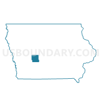
Outline

Summary
| Unique Area Identifier | 582204 |
| Name | BEAVER TWP Voting District |
| County | Guthrie County |
| State | Iowa |
| Area (square miles) | 40.94 |
| Land Area (square miles) | 40.94 |
| Water Area (square miles) | 0.00 |
| % of Land Area | 100.00 |
| % of Water Area | 0.00 |
| Latitude of the Internal Point | 41.55581960 |
| Longtitude of the Internal Point | -94.41992700 |
Maps


Graphs
Select a template below for downloading or customizing gragh for BEAVER TWP Voting District, Guthrie County, Iowa


Neighbors
Neighoring Voting District (by Name) Neighboring Voting District on the Map
- JACKSON TWP Voting District, Guthrie County, IA
- JEFFERSON TWP Voting District, Adair County, IA
- LINCOLN TWP W/O STUART Voting District, Adair County, IA
- PENN TWP Voting District, Guthrie County, IA
- STUART TWP W/O STUART Voting District, Guthrie County, IA
- THOMPSON TWP W/O CASEY Voting District, Guthrie County, IA
- VALLEY TWP PART W/O GUTHRIE CENTER Voting District, Guthrie County, IA
- WALNUT TWP W/O CASEY Voting District, Adair County, IA
Top 10 Neighboring County Subdivision (by Population) Neighboring County Subdivision on the Map
- Valley township, Guthrie County, IA (1,823)
- Stuart township, Guthrie County, IA (1,064)
- Lincoln township, Adair County, IA (926)
- Thompson township, Guthrie County, IA (623)
- Beaver township, Guthrie County, IA (599)
- Penn township, Guthrie County, IA (524)
- Jackson township, Guthrie County, IA (308)
- Walnut township, Adair County, IA (176)
- Jefferson township, Adair County, IA (163)
Top 10 Neighboring Place (by Population) Neighboring Place on the Map
Top 10 Neighboring Unified School District (by Population) Neighboring Unified School District on the Map
- West Central Valley Community School District, IA (5,805)
- Guthrie Center Community School District, IA (2,648)
- Adair-Casey Community School District, IA (2,014)